As we approached Norfolk, Virginia, the seagrasses, undeveloped acreage, and serenity of northern North Carolina gave way to sirens, horns, generators, train whistles, tug boats, and the hussle bussle of a busy port.
Here are some pictures of a new high-rise bridge which opened this year, replacing a bridge which opened only on the hour! That restricted opening time made things very difficult, so everyone appreciates this new bridge (well, except maybe the tax payers!)
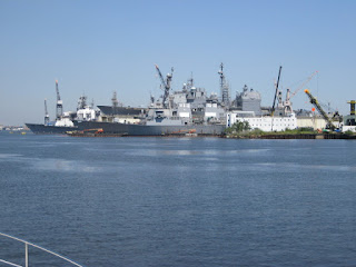 Norfolk is home to the largest Navy base in the world along with one of NATO’s two Strategic Command headquarters. It also has the corporate headquarters of Norfolk Southern Railroad. The region plays a vital role in defense contracting, with particular emphasis in the shipbuilding and ship repair businesses. Many of the largest international shipping companies also are headquartered in Norfolk.
 “Security” boats (above) guard the numerous aircraft carriers and other Naval ships docked for repair, including the USS Harry S. Truman, which we saw in port.
Working our way past Norfolk, we entered Chesapeake Bay which, thankfully, welcomed us with calm waters. As this is a huge body of water (200 miles long, 30 miles wide), with the right elements, the Bay can be very rough.
Long range cruising is definitely not like driving a car! It’s not as simple as putting your car in “drive” and zooming down the highway, stopping for the night at one of numerous hotels when you’ve had enough. Long range cruising, such as we’re doing, is kind of like a puzzle where you have a number of variables to consider in determining the most timely and efficient way to safely reach your destination. Of course, evaluation of the weather is really job one; and that entails more than watching The Weather Channel! (What feels like a nice day on land can be entirely different on the water.)
John finds it an interesting challenge to examine our day’s cruise and, depending on where we are, look at those variables which impact our progress. These could be tidal currents or bridges and locks with restricted openings. Based on these variables, we determine the time we start our day (usually at 7 am, but occasionally at 8), and consequently can determine the approximate arrival time at our destination (usually 4-5 pm). Also, with regard to bridge openings, we make appropriate speed adjustments. This is a major reason that we really appreciate having the ability on the Krogen Express to vary our speed (running from 8 kts up to twice that, if we want to).
In order to most efficiently plan the day you have to have good information……currents and their strength and direction, locations of bridges and how often they open (some are “on demand”, some are on the half hour, others on the hour), We are able to find all this information on an app we use on our IPAD from Garmin. It incorporates information from the data base of a cruisers guide called Active Captain. (www.activecaptain.com) It provides info about bridges/schedules, marine facilities, fuel prices.