It didn’t take this trip for me to realize how dependent I have become on my devices. It’s not that I’m in to social media or habitual texting with my friends or anything (heck, I still use my index finger to text!), but I do use my phone a lot. If I want to look up the meaning of a word, I go to “Dictionary”. If I want to know the weather, I go to one of my many weather apps. If I want to research something I go to “Mr. Googlies”. Even writing this blog I am dependent upon the internet! After Harpswell (just west of Boothbay) we began encountering spotty cell service and since our internet is cellular based, it sometimes puts us in a bind! (Between Florida and this area of Maine, there is only one 50 mile stretch in northern North Carolina where we have not found reliable coverage.) So, yesterday we were out of business. Today, we are good! Yay!! I’ll take what I can get!
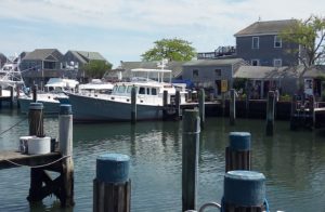
Our weekend in Boothbay was “highly productive” as John would say! It’s a cute town, although a tad on the touristy side. We spent 3 nights at a dock, tucked in behind a gigantic catamaran and a 100+ ft sail boat. We were especially thankful for our location one night in particular when the wind was hard blowing right up the harbor. But we were protected by the cat and sailboat, so had a restful sleep.
The afternoon of our arrival (Friday) we donned our backpacks and walked a mile plus to the grocery store. We picked up lightweight things that we needed……eggs, bread, bagged lettuces…..and walked the mile back to the boat. Provisioning on the boat is a little bit art and a little bit science! As with our devices, most of us are really dependent on our cars. If we forget an ingredient for a recipe or need to pick up dinner, we think nothing of jumping in our car. Not so on the boat. Meals take thought and planning. I make a monthly chart of what we’re going to eat for lunch and dinner everyday so that I have the right supplies and ingredients ahead of time. Up here, especially, I never know when I will get to another grocery store; and oftentimes they are far upland off of the major roads. It’s tricky too, to manage the consumption of produce……you want to eat it while it’s fresh, but not so quickly that it’s gone before you can replenish! Our previous trip to the store was in Freeport, almost 2 weeks prior to our visit to Boothbay; so it was time for a major haul.
I had been in touch with a dear, long-time friend who lives in the area for a visit. After a fun lunch on Sunday and a good catch-up chat, she graciously offered to drive us to the grocery store.  Otherwise we would have had to take a taxi, as there are no Lyfts or Ubers in Boothbay!
During our visit, this is one of the classic places we “dined”…..Dunton’s Doghouse….just a 5 minute walk from the boat. They had some of the best clam chowder we’ve ever had AND an absolutely perfect lobster roll. The owner has this shack (and picnic tables) set up in his front yard (how he ever got zoning for that we’ll never know!). When we 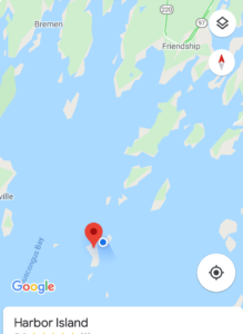 read the reviews they were almost all 5-stars, altho I would not classify this as a “5 star” restaurant! John, who loves dives, was in heaven!
Following our visit to Boothbay, we departed for Harbor Island, just south of Friendship, passing the Pemaquid Lighthouse on the way.
You may be wondering how we find 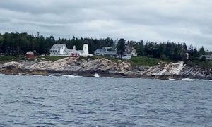 these gunk holes. We rely for the most part on two online sources….. Active Captain and MITA (Maine Island Trail Association). Also, one of our former owners also gave us a wonderful book “A Cruising Guide to the Maine Coast” by Hank and Jan Taft. Active Captain is something we have relied on for years. It is an excellent “crowd sourced” cruising guide. It gives all kinds of great information for cruisers……marinas, boat ramps, where to anchor, entry into anchorages/marinas, exposure to
  the winds, where to take your dog ashore, scenery, holding, shopping, boat repair facilities, etc. MITA has given us great information on anchorages, trails, and getting ashore. This captain does his homework, too. He studies the weather, winds, wind direction, depths, and currents. And then I ask, “is there an easy place to take the dogs ashore?” !!
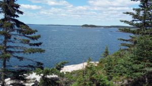
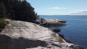
I think Harbor Island is one of my favorite stops so far. It has a lovely view, walking trails, and a nice beach for landing the dinghy. Here are some pictures from our walk yesterday.

 blueberry muffins and coffee to each visiting boat every morning! They were absolutely delicious!
 Boothbay Harbor) and a pretty view from the shower (which John enjoyed).
 within a 10 mile area east of Harpswell and west of Boothbay .
 The next morning we got a friendly visit from “Bob” who, it turns out, owns both balls. Normally his personal boat occupies one of the balls but, this summer being what it is, he didn’t put his boat in the water. He was a really friendly guy and we had a very enjoyable conversation with him.
 opportunity to walk the trail and get some exercise!
 nearby. Nothing could be better for this captain than a cell tower AND seclusion at the same time! We launched the dinghy and made a trip ashore for a walk through the preserve, landing at a nearby shelf of rock, easily hopping ashore. But…. that was at high tide. Five hours later, at low tide, was another story. The tides are so severe here that our once accessible landing zone was now off in the distance and we were faced
  with muck and rock completely covered in seaweed. I set Zoey down on what I thought was rock but turned out to be muck. Ugh. She looked like she had little gray booties on! I couldn’t help but think of my friend who has a gorgeously groomed Sheltie and how aghast she would be at the thought of having to take her dog ashore through this stuff! It was a perilous journey to land on the seaweed and back again, but we made it. And then of course we had to do the same thing again the next morning, 12 hours later. It’s interesting to watch the process of them pulling up the traps, etc. Kind of
  like our own up-close-and-personal “Deadliest Catch”, without the 30 foot waves!
 really something else. It’s like your glasses are dirty or you have something in your eye! It seems relentless, although locals tell us that this much fog is unusual for mid-July. It’s noon as I write this and my visibility is about half a mile.
 Next stop was Boothbay Harbor Yacht Club. On the way in we passed this very cool lighthouse called the Cuckholds Lighthouse. Construction of the lighthouse began in 1892. In 2004, deemed excess to the United States Coast Guard, the lighthouse was rescued from complete decay and/or destruction by a small group of local citizens. Over the next 10 years the group raised funds and local businesses donated design expertise, building materials, and other resources to restore the light tower, rebuild the keeper’s house and the boathouse. Following this the lighthouse became an inn with two guest rooms. It closed in July of last year when the innkeepers, a husband and wife team, retired.
 the public and they provide launch service which was a nice perk! The Yacht Club is across from the harbor, so we could look over and anticipate our visit into town in the following days. When we are out in these isolated anchorages with almost no interaction with other people and certainly no retail, coming to a little town like Boothbay Harbor Maine (full-time population of 2,200) is like going in to the big city! After the night there, we went into Hodgdon Marina for the weekend.
 strand the dinghy on the shoreline, nor do we want the tide to come in so that the dinghy is floating in 4 or 5 ft of water.
 The fog continues to baffle me….how it suddenly appears in the middle of the day, why it stays even when the sun is out, why it doesn’t burn off more quickly! But it comes with the territory, and it’s just
  something Mainers are used to. This is a pretty typical morning view (especially last week when it was very cloudy and a bit rainy ). But then here’s a different view from the same anchorage when the sun finally came out! It’s beautiful, isn’t it? It’s something I really appreciate up here, and probably take for granted at home in Florida.
 Before we left Snow Island (when the sun had finally appeared!) John donned his wetsuit and did some waterline clean up. The water was chilly, and took some getting used to, but it was good to get
  that job done. This is a picture of John doing the same thing last year in the Bahamas; except he was standing in 5 feet of water!! After lunch we pulled up the anchor, and off we went. This was our view as we exited. See what I mean about the fog? This was at noon! It’s almost mystical!
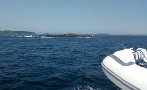 After 2 nights at Snow we departed for Harpswell’s Dolphin Marina. We passed a lot of these rock islands which fortunately are on the chart. These pictures do not nearly portray the potential threat these things pose! They are quite imposing and we give them a very wide berth!
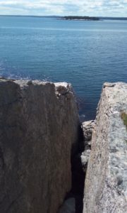
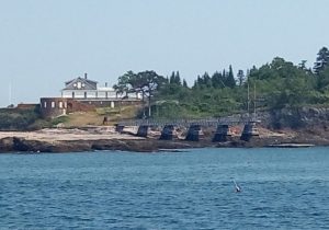 Park, formerly the home of Admiral Robert E. Peary, the Arctic and North Pole explorer. Although he died in 1920, his family continued to live in the home until they donated it to the state in 1967. It is now a National Historic Landmark.
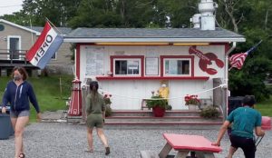 Just outside the marina grounds is Erica’s…..a fabulous and pretty typical little fish shack with picnic tables and the most fabulous lobster rolls!
 I imbibed two days in a row!
 the basin. It’s very much like being on a lake! We are surrounded by pine trees and rock outcroppings along the shore. It’s very serene and peaceful. You never know what you’re going to find in terms of other boats when you approach an anchorage, so upon arrival we were pleasantly surprised to see that we were the only ones (with the exception of a few weekend day boats)!
 rainfall in late spring has pushed almost half the state into drought conditions, and there’s little relief in the forecast……” So much for forecasts! It’s raining so hard that even if we were at home, and I had my much missed “back door and yard,” our dog Zoey would not even consider going out! She does not like the rain! Period.
 This is one of the times I am especially thankful for our covered aft deck. After we’ve been ashore in the rain, we can get back on the boat and be covered while we take off our dripping wet rain gear coats and pants. Otherwise we’d be entering directly into the salon, dripping water all over! And I’m also very appreciative of a dryer for the many wet towels we accumulate on days like this. Zoey loved being wrapped in a warm towel for her after-outing nap!


 on our radar. Fortunately there was very little boat traffic and we were able to keep tabs on the lobster floats. Our destination, Jewell Island, was approaching and we were struggling to see even the outline of trees on the islands surrounding us. But the sky was very bright. It seemed like the sun
  was so close, yet so far. At one point, I picked up my binoculars, looking for buoys and identification points. As I took them off my eyes, suddenly the sun appeared and the area was totally clear! It was the wierdest experience! We were able to easily enter the anchorage and get set before the fog returned. And return it did! The next 2 days were thick fog, altho we did have minutes of clarity.
 far, there are trail markers and leftover camp fires; but I have not seen one piece of trash, not even a cigarette butt! Visitors appear to be very respectful of them, and of each other.
 Wednesday morning, after our 2nd night there, we departed – once again in the fog – for Lower Goose Island. Upper Goose Island is to its north, 2 islands – The Goslings – are to its south. There is a mooring field here, so we helped ourselves, as borrowing a mooring ball is common practice here in Maine. (It was the easiest, most effortless pick-up I’ve ever done!) We took the dogs ashore to one of The Goslings (pictured)
 and then settled in for the evening. The air cleared and we had one of the prettiest skies of the trip so far. Truly, it was a sign of good things to come. As you know, “red sky at night, [cruiser’s] delight!”
 looks cold, but it’s really not that bad! I’m so appreciative that, when we return to the boat, we can spray off our feet with warm water from the transom shower!
 Billy Joel, Zach Brown, Nat King Cole, Ray Charles, Boston, and more!
 do for dinner! And since this area is all new to us, we spend a lot of time researching our destination, what we will find, what it offers, where to take get the dogs ashore. This morning I had a one hour “Snapchat” training session with my nephew. In reality I don’t know how much I’ll ever use it, but he and I had a lot of fun and laughs! I also had a text exchange with one of our former owners who summers in the area and has good local knowledge. Then it was time to make lunch!
 where tides are high. Here in Maine the tides are 7-8 ft versus Florida where the tides are 2-4 ft. Because of the method in which moorings are secured they use a much shorter scope than when anchoring. For instance, our swing here on a mooring is 20-25 ft. If we were on at anchor, our swing would be 200 ft. Therefore 2-4 times as many boats could be accommodated in a particular area.
 We cruised into Camp Ellis (altho it’s not a camp, but more like a seaside hamlet) on the Saco River where there were supposed to be 2 free moorings. Both were occupied, but…….then I spotted a third…. and it was available! John made a quick u-turn, I grabbed the line, secured it, and we were set! Lunch completed, we lowered the dinghy and took the dogs ashore for a walk. It was an unbelieveable 85 degrees, so the walk was short. But it allowed us to spot a good take-out dinner spot for the next night!
 you an idea. One also shows the severity of the tides! See those mooring balls sitting on land?!
 family after a wonderful week in Nantucket, but it was time to move on. Looking back as we
  cruised out of the marina, we waved goodbye, proceeding then past Brandt Point Lighthouse proudly wrapped in the American flag.
 dense fog when we got up at 5 the next morning. Dogs walked, dinghy stored, and anchor pulled by 6 we set off for the canal. Things cleared nicely making for a visibly manageable trip.
 to Marblehead. This is a charming town with homes from the 1800s. It has a rich history in fishing and yachting and was once a major shipyard. It is often referred to as the birthplace of the American Navy. As is the case with much of the New England coastline, it is bordered by rock. The town was named Marblehead by settlers who mistook it’s granite outcroppings for marble. During our walk around town we came across a gift store that had some kitchen towels in the window, and this one really made me laugh!
 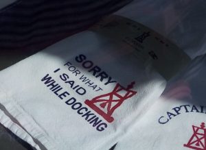 Any boating couple can really relate to the quote…..”Sorry for what I said while docking”. Fortunately John and I don’t have too many moments when we regret our words, but there can be tense times on occasion.
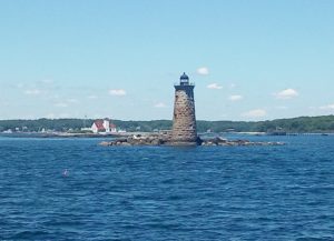 on this blog; but it might be a challenge! Everything along the coastline in these historic, coastal towns is “quaint” and “charming”! Kittery Point is no exception! The Whaleback Lighthouse greeted us as we approached. This is the view up the Piscataqua River off our stern.
 of gawkers! Afterall, the Krogen Express is a head-turning vessel! Sometimes we feel like we are an exhibit at the zoo! People stop and stare. They call on the radio. They watch as we dock or pull into an anchorage or mooring field. It’s flattering, but it can also be a bit intimidating, especially when you’re trying to have a smooth docking or a perfect mooring pick-up.
 school graduates. The fire department and police, along with an array of cars decorated with blue and white balloons, honked and blew sirens! People stood along the side of the road clapping and cheering!
 foremost whaling port in America. Today it has a year-round population of 17,200 residents. In 1830 it was the third largest city in Massachusetts!
 which provides only minimal wind protection. In addition the harbor is large. Consequently there is a lot of fetch, and it can get very choppy. There are whitecaps out there now. A dinghy ride ashore would be miserable in these conditions.
 or rather an “anchor during the wind!” Lake Tashmoo is surrounded by big trees and banks, and it’s a very protected spot to drop the anchor. In fact we loved it so much we stayed 5 days! After moving up the coast fairly quickly, we enjoyed the opportunity to relax, do some boat projects, take walks, and read (something we never seem to have
  time to do). John likes espionage and “whodunnit” books. I prefer biographies and fiction-based-on-fact books. In fact, I read “The Life and Times of the Thunderbolt Kid” by Bill Bryson. It’s an autobiographical book about a guy who grows up in the 50s and 60s, the peculiarities of his family and his adventures, etc. etc. I laughed out loud so many times; and when I would try to read a section of it to John I could hardly get the words out I was laughing so hard!
 But when you have two dogs with you who like to sniff everything, it’s more like 40!
  Our walk there was pleasant but there wasn’t a lot to do as not much was fully open. Another day we walked to John’s Fish Market for another clam-chowder taste test in our never ending quest to find the best! Our opinion: Lobster House in Cape May is still number 1.
 southeast to Edgartown.
 mansions for their families with ornate top floor rooms called
  were intended or regularly used for this purpose. They were frequently built around the
  Residents here have beautifully restored old captain’s homes. Local shops and hydrangea boxes line the streets. Diners gather at outdoor patio restaurants on the harbor. It’s a charming village.
 evening! I couldn’t resist taking a picture. As you have probably figured out, I am a big fan of the American flag!
 (And it has the best homemade donut shop in the world!) The anchorage is about 20 minutes down the inlet off the north shore of Long Island Sound (see picture of red building). There’s room for about 4 boats there; but this time we were the only ones! Nothing was open in town so we just hung around the boat, took short walks.
  We have friends from home who have a summer house near here, so they came to visit us, and we had a great time catching up as well as discussing all the ins and outs of world events.
 the sign was meant just for us! At the dinghy dock, we looked back and got a clear shot of Daystar way off in the background. Typically there would be so many boats, there would be no way to see her.
 the anchor by 6:45. It was a couple of hours to Point Judith across Block Island Sound where we filled up the tanks at a commercial fuel dock, and we also
  purchased right-of-the-boat swordfish and a quart of lobster bisque. (We’ll be eating right tonight, I’d say!)